|
The
Hemlock Stone
By Mr Emsley Coke/Mr
Samuel Page,The Hemlock Stone, Transactions
of the Thoroton Society, 10 (1906)
By Mr Emsley Coke
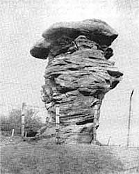
Various theories
have been put forward in explanation of the Himlack
(or Hemlock) Stone, and may be divided under two heads:
(1) That it is entirely the work of nature; (2) That
it is mainly the work of man.
 |
The
Hemlock Stone. circa 1906 |
At one time it was
thought to have been cut out by the Druids as an object
of worship, and later opinion suggested the remains
of a quarry. In the memoirs of the Geological Survey,
published in 1880, Mr. Aveline says: “Twenty
years of further observation would incline me now
to place more stress on sub-aerial denudation than
on marine. I believe that whatever may have been the
first denuding agent, sub-aerial agencies have given
the finishing touches to the moulding of the physical
features of the district as we now see them, and that
the striking pillar of rock, the “Himlack Stone”
has slowly worn into its present shape after the country
was raised above the sea for the last time.”
I entirely agree with
Mr. Aveline in this; the adjoining Bramcote and Stapleford
hills are of the same formation and no doubt are the
remains of strata which at one time extended over
the entire district. The “Himlack Stone”
is probably the last remnant of a harder piece of
the rock which has taken longer to remove.
There is no evidence,
so far as I can learn, that any quarry was worked
in the vicinity, and I believe the ground has been
examined to see if there are any remains, but nothing
was found.
It is quite possible
and likely that this stone was associated with worship
in ancient days, most of the striking natural objects
usually have been.
Mr. Shipman considers
the Hemlock Stone the remains of a huge hill which
has been washed away and crumbled by the dislocations
or “faults,” and by weather, its origin
somewhat resembling that of Nottingham Castle rock.
The upper part of it, of the hill at Stapleford behind
and of the hill at Bramcote in front, he considers
to be Keuper, he and Mr. Wilson thus differing from
most geologists, who regard it as Bunter, like the
Castle Rock. The lower part is considered to be mottled
sandstone. The particles of the upper portion maintain
their firmness through chemical action, the substance
apparently being sulphate of barium.
Mr. Samuel Page holds
that the use of the Hemlock Stone for Druidical rites
may be definitely traced. He believes it to have been
a Tothill, one of those eminences, natural or artificial,
which were dedicated to the worship of the Celtic
deity, Teut (Egyptian “Thoth”). He sends
us the following paper in support of this theory.
By
Mr Samuel Page, F.R.N.S.
Though there may be
difference of opinion as to the origin of the Hemlock
Stone, yet, in my view, the use of it for Druidical
rites may very definitely be traced. I would refer
to a letter in Hone’s Year Book, 1831, page
867, on the subject of the Toothills, from the text
of which I take the following extracts :—
“The able manner
in which you have elucidated the antiquities and customs
of Britain, and especially the ‘Midsummer Fires,’
and other Pagan relics, prompts me to draw your attention
to what, though intimately connected with them, you
seem hitherto to have neglected or overlooked namely,
the Toot Hills, formerly consecrated to the worship
of the Celtic deity ‘ Teutates,’ many
of which still remain with scarcely any alteration
of their designated names. . . . Mr. Payne read a
paper before the Royal Society of Literature, in 1829,
in which he identifies the Celtic Teutates with that
benefactor of mankind, who, from the invention of
various useful arts, was worshipped in Egypt and Phoenicia
under the name of Thoth, in Greece as Hermes, and
by the Latins as Mercury. To shew the connection between
Tot and Teut and the Egyptian Thoth, it may also be
remarked that Bruce says the word Tot is Ethiopic,
and means the dog-star; now the Egyptians represented
Thoth with the head of a dog, and Mr. Bowles remarks
that ‘the Druids cut the sacred Vervain at the
rising of the Dog Star.
There can be little
doubt, at any rate, that the Thoth of Egypt, deified
in the Dog-star, was transferred to the Phoenicians,
who derived their astronomical knowledge from Egypt,
and who ‘held their way to our distant shores
on account of commerce, thus, perhaps, leaving some
relic of their knowledge behind them; and indeed the
Egyptian Thoth, the Phoenician Taautus or Taute, the
Grecian Hermes, the Roman Mercury, and the Teutates
of the Celts (so called from the Celtic Du Taith,
Deus Tautus) are among the learned admitted to be
the same. . . .
A stone was the first
rude representation of Tuisto, or Teut, and these
dedicated stones were placed on eminences, natural
or artificial, most commonly by road sides, and hence
called Tot-hills or Teut-hills, and in various parts
of the kingdom are so called at present. These hills
would, of course, still remain after the Druidical
rites were abrogated by the Romans; and as that people
paid especial attention to the genii loci of the countries
they conquered, and, besides, considered these Teut-hills
as dedicated to their own Mercury, they would probably
venerate them equally with the conquered Britons.
. . ‘According to my idea,’ observes Mr.
Bowles, ‘Thoth, Taute, Toute, Tot, Tut, Tad,
Ted, Tet, are all derived from the same Celtic root,
and are in names of places in England, indicative
of some tumulus, or conical hill, dedicated to the
great Celtic god, Taute, or Mercury.’”
Many names of places
derived from Taut are scattered all over the country,
to mention locally, Toothill Lane, Mansfield; Toton,
near Nottingham; Toth ill, near Alford, Lincolnshire;
Totley, Derbyshire; Tatenhill, near Tutbury; which
latter name is also of the same derivation. At least
sixty names are given in Hone’s Year Book.
But it will be asked,
what connection has all this with the Hemlock Stone,
and where is the Tothill to be traced?—(the
name Hemlock, by the way, I think, was sometime Cromlech,
though the late Mr. Lowe gives a different derivation).
If we look around for Tothill I think we need not
go very far. An ancient little stream called the Tottle
Brook rises near Trowell Domesday Torwell—and
flows not very far from the Hemlock Stone. Further
on, it forms the boundaries of some parishes, and
then pursues its winding course to the distant Trent,
into which it empties itself opposite Wilford Church.
How probable it is that this little rivulet acquired
its name many centuries ago from an important Tothill
close by! Mr. F. W. Dobson informs me that there are
certain streams in Wales which undoubtedly derive
their names from local Cromlech stones, and this strengthens
my theory.
To my mind, at least,
there is here some evidence that this Hemlock Stone
was the Tothill, and that here the Druids celebrated
their worship, brought their sacrifices, and lit their
prodigious fires on the eves of May Day, Midsummer,
and the 1st of November. Probably, owing to the action
of nature during prehistoric ages, they found the
stone in much the same shape as we see it now, though,
from denudation, less in height from the level of
the ground, and utilised it for their purposes. Of
the Druids and their rites our knowledge is limited,
but I venture to suggest that in the name of this
little stream may lie the key to some of the antecedents
of the Hemlock Stone, the mystery of which has so
long puzzled the antiquary.
Mr. Page’s theory
is disputed by another correspondent, who considers
that there is no evidence connecting the stone with
Druidical observance, and who suggests that the etymology
of “Toothill” is merely an example of
the process known as the reduplication of synonyms.
The name, as well as
the origin and use, of the Hemlock Stone is a matter
of speculation. It has been suggested that it was
named from the plant Hemlock, which was greatly celebrated
by the ancients, and which may have grown in abundance
about the column.
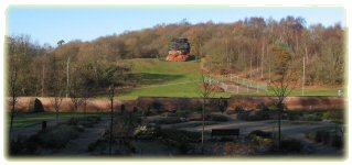
A brief stay was made
by the party at the Hemlock Stone, most of the company
having already inspected it.
----------------------------------
By Emsley Coke/Samuel
Page, The Hemlock Stone, Transactions of
the Thoroton Society, 10 (1906)
Thanks to
A. Nicholson for the use of text and pictures: www.nottshistory.org.uk |


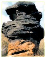

.jpg) pinnacles
are masses of rock, locally cemented, and made intensely
hard by a vertical dissemination of calcareous matter
(contained in percolating waters) before the removal
of the surrounding mass took place. The surrounding
and softer mass has been gradually removed by subaerial
denudation, leaving the harder or cemented portion
standing in the shape of pinnacles—objects of
interest to the geologist, and a wonderful puzzle
to the superstitious and uninformed.
pinnacles
are masses of rock, locally cemented, and made intensely
hard by a vertical dissemination of calcareous matter
(contained in percolating waters) before the removal
of the surrounding mass took place. The surrounding
and softer mass has been gradually removed by subaerial
denudation, leaving the harder or cemented portion
standing in the shape of pinnacles—objects of
interest to the geologist, and a wonderful puzzle
to the superstitious and uninformed.